Your Cart is Empty


A patchwork of farmland, windswept moorland, rolling hills, wooded valleys, extensive wetlands and a wealth of intriguing, visible human history from the ancient to the modern, Somerset boasts a fantastic variety of landscapes and terrain to explore. This is a region that’s famous for its cave-aged Cheddar cheese and farmhouse cider, plus cream teas to rival those of Devon and Cornwall. It’s got Glastonbury, home to a ruined abbey and a steep-sided tor as well as the internationally-famous music festival; Wells’ awe-inspiring Gothic cathedral; and Bath’s honeyed Georgian splendour and natural thermal spa. The county’s natural wonders include Exmoor National Park, a dark skies reserve edged by some of the best coastal walking in the country; the relatively undiscovered hills of the Mendips and Quantocks; and the expansive flatlands of the Somerset Levels, home to the UK’s tallest bird, the common crane.
We’ve lived in, or on, the edges of Somerset for much of the past fourteen years, and we’re still regularly surprised by the discoveries we make while we’re out walking, running or cycling on its footpaths, bridleways and forgotten lanes. Day Walks in Somerset is a celebration of some of these.
A collection of 20 of our favourite coastal, moorland and rural walks, the routes are designed to offer an enjoyable day’s walking with distances ranging from 11.2km (7 miles) up to 24.2km (15 miles). Here’s a selection to get you started:

Brean Down from Walborough Hill. © Jen and Sim Benson
OUR FAVOURITE FAMILY WALK
Brean Down
Kids like a point to a walk – something to aim for like a summit, castle or café. They relish interesting, interactive trails with signs to follow, trees to climb, hills to roll down or ruins to explore. Points of interest like trig points and historical landmarks spark conversations and questions that keep the miles ticking by.
The 20.6km (12.8-mile) Brean Down walk from the book has all of this and more. If you’re walking with younger children, it’s also easy to shorten the route to a very achievable 4km (2.5 miles), beginning at Brean Down National Trust car park instead of Weston-Super-Mare, missing out a few miles of flat coastal walking and getting straight to the exciting bit (and the café).
From the start there’s an adventurous climb up a flight of steps to reach the top of the downs. From here, the walk follows the inviting ridgeline west to bag the trig at the summit. Keep your eyes peeled for the remains of a Bronze Age burial mound and the site of a Roman temple. You can also see Palmerston Fort standing guard at the headland, built to deter a Napoleonic invasion (which didn’t happen) and then adapted for use in both WWI and WWII. The grassy trail down to the fort is perfect for little legs to run or roll and there’s loads to explore once you get there, with handy information points to explain what each room was used for.

Bridleway down towards Short Combe. © Jen and Sim Benson
OUR FAVOURITE DOG WALK
Northern Quantock Hills. 11.2 km (7 miles)
Our hyperactive springer spaniel accompanied us on almost all of the walks for this book. We asked him which was his favourite, but he loved them all! This loop around the northern Quantock Hills is ideal for dogs, staying well clear of farmland and roads, although you will still encounter wildlife that won’t want disturbing.
A designated AONB since 1956, the Quantock Hills stretch for 25 kilometres between the Vale of Taunton Deane in the south and Kilve on the Bristol Channel in the north. A place that inspired Coleridge and Wordsworth, the area is networked with footpaths and bridleways, many leading steeply up from the surrounding villages to reach the crest of the hills where far-reaching views extend in all directions.
Our route makes the most of this high ground, setting out with an ascent of the trig-point-topped summit of Black Hill. In good weather the views from here reach across the Bristol Channel to the Gower Peninsula, Exmoor, Brean Down and the Hinkley nuclear power station. An ancient drovers’ road traces the main ridge of the hills, ticking off the tops of Thorncombe Hill, Throncombe Barrow and Beacon Hill. Another drovers’ route – The Great Road – visits Longstone Hill, where an ancient Long Stone awaits discovery on the eastern slopes. Dropping into the wooded gorge at Short Combe, refreshingly cool on a hot day, the route winds alongside a pretty stream and through moss-covered ancient oak trees. The steep ascent up the opposite side of the gorge is handsomely rewarded with another outstanding viewpoint at Higher Hare Knap, from where it’s an enjoyable amble along the ridge back to Black Hill.
N.B. Dogs must be kept on a lead on open access land between 1 March and 31 July to protect ground nesting birds. Sheep and ponies graze year-round on the Quantocks so dogs must be in sight and under control at all times.

Wimbleball Lake Trail. © Jen and Sim Benson
OUR FAVOURITE FLAT(ISH) WALK
Around Wimbleball Lake. 13.4km (8.3 miles)
None of the walks in Day Walks in Somerset are completely flat, but the circumnavigation of Wimbleball Lake doesn’t have any big hills. There’s something satisfying about completing the full loop, and the wild, remote setting and committing nature of the trail on the far side of the lake means it all feels like a proper adventure.
The walk heads out along the busier western shore, passing the activity centre and flotilla of moored boats before crossing the dam. Built in 1979 to flood the valley and create the reservoir, the view as you cross – nearly fifty metres down – is definitely vertigo-inducing. The peaceful eastern shore, which winds through ancient woodland, buzzards mewing overhead, is a wonderful contrast, with long sections of remote and fairly inaccessible lakeside trail. The home stretch passes bird hides and a nature reserve, finishing at the café visitor centre.

OUR FAVOURITE ACCESSIBLE WALK
Kennet and Avon Canal. Full route: 14.6km (9.1 miles). Accessible route: 4.5km (2.8 miles)
The Kennet and Avon Canal traverses the country from Reading to Bath, for the most part accompanied by a well-maintained, surfaced towpath that’s popular with walkers, runners and cyclists. Our route that takes in the canal heads out along the towpath but returns over the Bath Skyline, which is hilly and off-road with steps and gates. However, the stretch between Bath and Bathampton makes for a scenic and enjoyable buggy – and wheelchair-friendly out-and back, and one we did often when our kids were tiny.
For step-free access join the towpath at Beckford Road in Bath or at Bathampton (point 6 in the book), where there’s a floating café as well as a pub with a beer garden. This section is wide and well-surfaced, with waterbirds, boats and pretty gardens to admire as you go. Within easy reach of the canal in Bath are Sydney Gardens, where there’s an excellent kids’ playground, and the café at the Holburne museum.

Burton Wood. © Jen and Sim Benson
OUR FAVOURITE RIVER WALK
Burrow Mump and West Sedgemoor. 24.2km (15 miles)
Edged by the Mendip and Blackdown Hills, the Somerset Levels are an ancient coastal plain and wetland area, much altered to suit the adapting needs of people over thousands of years. Some sections of the ancient timber causeways known as the Sweet Track and the Post Track along the River Brue date as far back as 3838 BC, making them the oldest of their kind in Britain. Human history plays a strong part here, from Arthurian legends and hilltop churches to the engineering of the Bridgwater & Taunton Canal.
Set deep within the low-lying Somerset Levels and Moors, Sedgemoor is historically an area of marshland, much altered by human activity through draining and river ‘improvements’. Today it’s a fascinating area – a patchwork of flat grassland dotted with small, steep-sided hills (locally known as ‘mumps’), that would once have been islands year-round, and often become so over the wetter months when the local rivers spread and merge.
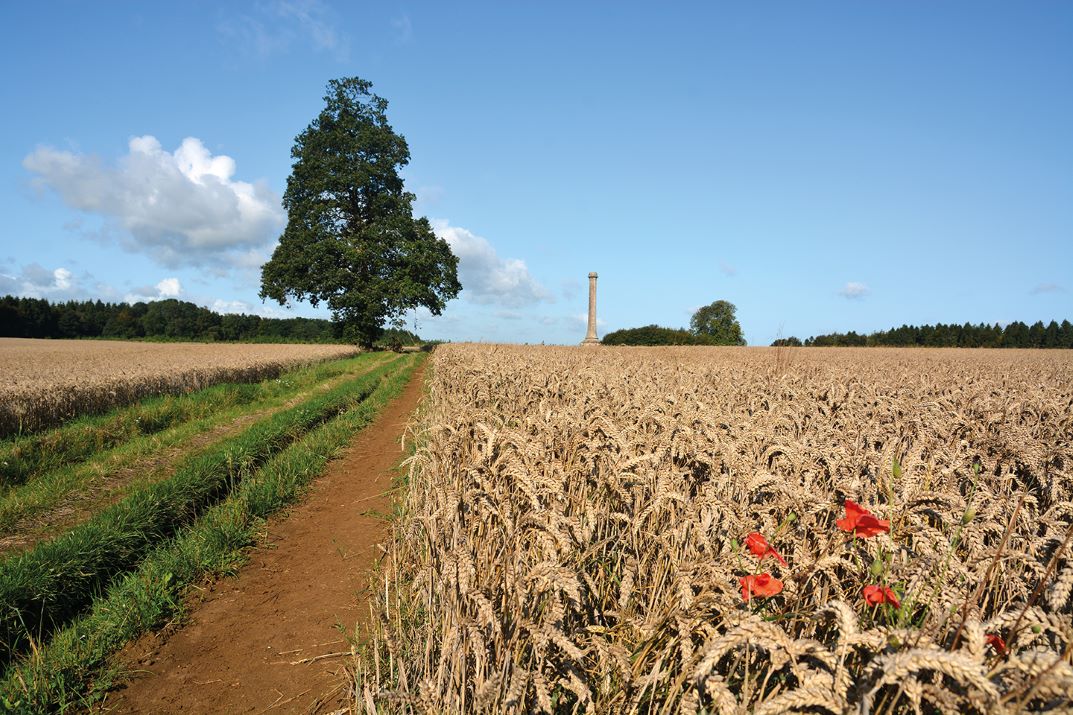
Our walk takes in a circuit of the West Sedgemoor RSPB reserve, offering ample opportunity to watch the vast flocks of wading birds in the summer and wildfowl in winter. It climbs the conical hill of Burrow Mump for great views across the Levels as far as Athelney, visited towards the end of the walk and once a hiding place of Alfred the Great. The ruins of St Michael’s Church on the mump’s summit are atmospheric and interesting to explore. From here the route follows sections of the East Deane Way, the Macmillan Way West and the River Parrett Trail, the latter of which follows the course of the River Parrett for 80 kilometres (50 miles) through the Levels. It also visits the Burton Pynsent Monument, built in 1767 by William Pitt (Pitt the Elder).

OUR FAVOURITE SHORT WALK
Ashton Court and Leigh Woods. Full route 13.3km (8.3 miles) or two shorter loops of 5.5km (3.5 miles) and 7km (4.25 miles)
While the routes in the book are typically long enough for a full day’s walking, some split well into two shorter loops, perfect for easier outings. Our walk around Ashton Court and Leigh Woods is one such route, comprising two neat loops that can be undertaken separately or as one, all within easy reach of Bristol and its excellent public transport links.
Loop one explores Leigh Woods, with its rare whitebeam trees and fascinating foliage including Bristol rock cress and Bristol onion. The path wends through the woods to reach the river Avon, following the Avon Trail with surprise views across to the dramatic crags of Avon gorge and up to Clifton suspension bridge. There’s a good climb up Nightingale Valley, which brings you to Stokeleigh Camp, an Iron Age promontory fort that makes the most of its lofty position above the Avon valley.
Loop two visits Ashton Court, a country park and mansion surrounded by 850 acres of wider estate. Despite its proximity to Bristol, it is home to some of Britain's rarest wildlife, including the green-flowered helleborine and the diminutive marsh tit. You’re also likely to spot some of the resident deer, of which there are four species – red, fallow, roe and muntjac. This loop can be started at Clifton Lodge West, just across Clifton suspension bridge from Bristol, crossing the deer park to reach Ashton Court Mansion with its courtyard café.

OUR FAVOURITE COASTAL WALKS
Selworthy and Bossington. 16.5km (10.3 miles)
Somerset has a long stretch of coast that edges the Bristol Channel between Avonmouth and the Devon border. From the mudflats around Weston-Super-Mare to the rocky, pebbly beaches and high headlands of Exmoor there’s a vast range of different landscapes to walk through. The South West Coast Path starts in Minehead and heads west around Devon and Cornwall to reach Poole in Dorset, 1,014km (630 miles) away, offering, in our opinion, some of the best coastal walking you’ll find anywhere on earth.
This walk follows a spectacular section of the coast path around an undulating loop of the Holnicote estate between Bratton Ball in the east and the old coast guard lookout at Hurlstone Point in the west. It links up higher and lower variations of the coast path: the lower, seaward trail is quieter, more technical underfoot, and makes the most of the dramatic scenery, with a series of steep-sided coombes demanding good grip and legwork. The return along the higher path affords grand views out across the Bristol Channel to Wales, easier underfoot but sometimes a little busier. It’s a cracking route – one of our absolute favourites in the book – topped off by the finish in picture-perfect Selworthy village and a cream tea at the Periwinkle Tea Rooms.